Hailstorm devastates Muswellbrook
Monday, 25 October 2004
Once again the weather showed its furry yesterday. A supercell thunderstorm yesterday afternoon has left a trail of damage through
Muswellbrook. The storm developed near Mudgee and then travelled east
- northeast. The storm hit Muswellbrook at approximately 5:20pm with strong to
gale force winds and 9cm hailstones. The hail was the main contributor to the
damage with insurance payouts expected to be in the millions. Roofing and car
damage was the most common damage.
This thunderstorm has caused the worst hail damage in the
Hunter since the November 1996 Singleton hailstorm. The size of the hailstones
were comparable as the hailstones recorded in the devastating April 1999 Sydney
hailstorm.
Thunderstorms were very active across all the Hunter
yesterday afternoon and evening, with many separate storm cells. Heavy rain,
strong winds and small hail were observed in a number of other centres,
including Maitland, Dungog and Singleton. The thunderstorms that hit these
centres were not related to the supercell that hit Muswellbrook, even though
many of them occurred around the same time.
Thunderstorm activity yesterday was not out of the ordinary
in regards to the atmospheric conditions. The surface temperatures were in the
mid to high 20's, the lower and middle parts of the atmosphere were very moist
and an upper low pressure still remained over the region following last weeks
heavy rain and strong winds.
|
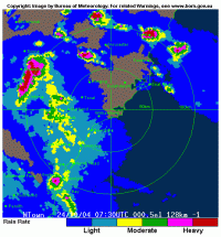 Radar image taken at 5:30pm. The supercell storm can be noticed by the dark red strip just east of Muswellbrook.
|
Storm Chase Summary of this event
by Jimmy Deguara (http://www.australiasevereweather.com)
This is by far the largest storm of the season so far (our
spring).
This event developed along a shortwave that destablised the atmosphere and
for once had at least some inflow from the east. Directional and speed shear
was more than ideal for supercell development.
David Croan, Geoff Thurtell and I with Jeff Brislane and Matthew
Piper intercepted a supercell with very large hailstones and transitioning
from a classic supercell to HP structure and then bowing out into a line
structure a couple of hours later.
The storms developed near Mudgee which is about two and half hours northwest
of Sydney and became more HP near Muswellbrook north of Sydney. It
devastated the region's grapevine crops. We intercepted this storm in its
classic supercell stage. It was an incredible event though my vehicle has
sustained more dents. I was very much concerned about the windsheild - some
were shattered in the event. The hailsize in the picture were not the larger
hailstone diameters observed - just whatever we could pick up when David
Croan dared lean out of the car:) 10 - 12cm hail were mentioned in this
storm backed up by David's estimates. In hindsight, we should have turned
back and surveyed the hail size and damage.
Jimmy Deguara is an avid storm chaser from Sydney, NSW and is
a co-webmaster for the
Australian Severe Weather website.
back...
|


 Hailstones collected near Muswellbrook. Photo courtesy of
)