|
|
|
Hailstorm outbreak across the Hunter
Monday, 13 December 2004
Thunderstorms this afternoon broke out across the Lower Hunter for the third
consecutive day. The thunderstorms produced hail, strong winds and brief heavy showers. Thunderstorm cells
developed rapidly after 4:30pm with hail and rain accompanied each cell. A
thunderstorm that hit Hexham at 5:30pm produced heavy rain, wind gusts to 70km/h and
the odd hailstone to 2cm in diameter. Afternoon traffic was almost at a stand
still on the New England Highway for several minutes. Approximately half
hour later another thunderstorm cell hit East Maitland, Metford, Thornton and Berry Park
producing 1 to 1.5cm hail.
Scattered thunderstorms had also occurred yesterday
and also on Saturday. None of the storms have been report as been severe in the
Hunter.
However, the storms all produced brief heavy showers with some areas receiving
small hail.
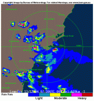
Newcastle 128K Radar image taken at 6:30pm. The radar shows a storm cell with hail hitting the eastern parts of Maitland and another cell with hail hitting east of Scone.
|
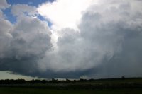
Photo taken at Tarro looking northeast at 5:45pm.
|
back...
|
|


)
)